

Marks
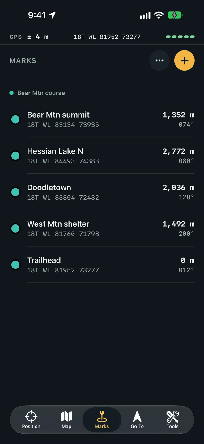
A mark is a point you want to reach or remember. The Marks tab lists them by folder, each with its symbol, name and grid, and its distance and azimuth from where you stand. A mark taken from GPS also shows the ± it was saved with.
A new mark
Section titled “A new mark”There are four ways to give a mark its position.
| Way | Start from |
|---|---|
| Type its grid | Marks ▸ + |
| Where you stand | Position ▸ Mark, or Here in the sheet |
| A distance on an azimuth | Project in the sheet |
| The map’s crosshair | Map ▸ + |
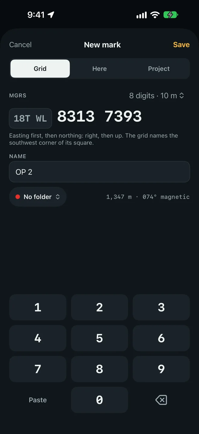
Every way ends in the New mark sheet. Type a Name or keep the suggested one (Mark 1, Mark 2), choose a folder from the menu under it, and tap Save. Save stays gray until the sheet has a position.
Type a grid
Section titled “Type a grid”-
On Marks, tap +. The sheet opens on Grid.
-
Check the zone and square in the box on the left, such as
18T WL. It is taken from where you stand, or from your newest mark if there is no position yet. To change it, tap the box, type the grid zone and the two letters of the 100 km square, and tap Use. -
Choose how many digits the grid has from the menu at the top right: 6 digits · 100 m, 8 digits · 10 m or 10 digits · 1 m. The choice is remembered.
-
Type the digits on the keypad: easting first, then northing. Right, then up. The dots show how many are left.
-
Tap Save.
A typed grid names the southwest corner of its square. 831 739 is the corner of a 100 m square,
the same point as 83100 73900. That is where a protractor plots it on a paper map, and where the
mark goes.
While you type, the line beside the folder shows how far the grid is from you and on which azimuth. A wrong digit usually shows there first.
Paste a coordinate
Section titled “Paste a coordinate”Paste on the keypad reads what is on the clipboard.
- An MGRS reference keeps its digits, so it lands where the same digits typed would. A reference with fewer than six digits is filled with zeros, which is the same corner.
- Anything else becomes a 10-digit grid: latitude and longitude in decimal degrees, in degrees and
minutes, or in degrees, minutes and seconds; UTM; a Plus Code; an Apple Maps or Google Maps link;
a
geo:link.
Where you stand
Section titled “Where you stand”Tap Mark on Position, or Here in the sheet. The sheet shows Where you stand, the grid and its ±. Wait for the ± to settle, then tap Save. The mark keeps that ± with it, and a GPS height when the phone has a good one. See Accuracy.
Project a point
Section titled “Project a point”Project puts a mark a distance away on an azimuth, From where you stand.
- In the sheet, tap Project.
- Type the Distance, m in meters.
- Type the Azimuth. The field’s label says its unit and its north, such as Azimuth, ° grid, as set in Settings.
- Check the grid that appears under the fields, then tap Save.
A magnetic azimuth needs the phone to know the declination. If it does not yet, the sheet says so: hold the phone flat for a moment, or use grid north in Settings.
At the crosshair
Section titled “At the crosshair”On Map, drag until the crosshair sits on the place and tap +. The sheet shows Crosshair and its grid. The resection and intersection tools save their answers the same way, with Save as a Mark.
Open a mark
Section titled “Open a mark”Tap a mark to start walking to it. See Go To a mark.
Swipe a mark to the left for Details and Delete. Touch and hold it for the full menu:
| Item | Does |
|---|---|
| Details | Opens the mark’s sheet. |
| Show on Map | Opens Map centered on the mark. |
| Copy Grid | Copies its MGRS reference. |
| Rename | Asks for a new name. |
| Move to Folder | Lists your folders and No folder. |
| Delete | Moves it to Recently Deleted. |
Details: name, symbol, folder, note
Section titled “Details: name, symbol, folder, note”The Mark sheet holds everything about one mark.
- Name.
- Symbol: fourteen shapes, among them a circle, a star, a triangle, a square, a flag, a tent, a drop, a cross, a car and a house. A new mark is a circle. The symbol is drawn in the folder’s color on the map and in the list.
- Folder.
- Note: a few lines on what is here.
- The position in six formats: MGRS, UTM, Lat, Lon, Degrees, minutes, Degrees, minutes, seconds and Plus Code. Tap a row to copy it.
- A line on how the position was got: Taken from GPS with the ± at the time, Placed on the map, Typed or worked out, or Imported from a file.
- Go To and Show on Map.
- Delete Mark.
Tap Done to close it. A saved mark’s position cannot be changed; make a new mark and delete the old one.
Folders
Section titled “Folders”A folder holds the marks of one course or one job, in the order you made them.
- Make one: tap the … button at the top of Marks, then New Folder, type a name and tap Create. Each new folder takes the next of eight colors.
- Put a mark in it: choose the folder in the New mark sheet, in the mark’s Details, or with Move to Folder.
- Send new marks there by default: New marks go to in Settings.
A folder appears in the list once it holds a mark. Marks with none are listed under No folder. A folder is also a course: see Go To a mark.
Select many
Section titled “Select many”- Tap the … button, then Select Marks.
- Tap the marks you want. The bar at the bottom counts them.
- Tap Move to send them to a folder, Export to share them as a file, or Delete.
- Tap Done to leave selecting.
Recently Deleted
Section titled “Recently Deleted”A deleted mark is kept for 30 days unless you change Keep deleted marks in Settings to 7 or 90.
Open Settings ▸ Recently Deleted. Each mark shows the days it has left.
- Restore puts it back.
- Swipe left and tap Delete Now to remove one for good.
- Delete All asks first, then Delete for Good removes them all. This cannot be undone.