
The map and the card
The map fills the window, under the toolbar, the layer list and the inspector, and everything you switch on in the layer list is drawn on it as the file styles it. A file opens framed on what it shows.
Map styles and names
Section titled “Map styles and names”The Map menu has the map’s choices: the toolbar’s Map button on every platform (its icon is the current style), and on the Mac also the Map menu in the menu bar. It has:
- Map Style: Muted, Standard, Satellite, Hybrid, Satellite 3D or Hybrid 3D (⌘1 to ⌘6 on the Mac). Standard is the default. The flat styles keep a file’s areas on top of the map; the 3D styles add terrain and buildings, and show the earth as a globe once you zoom out to a continent, so a file that spans the world is framed on the globe.
- Names on the Map: the placemarks’ names under their pins, as many as fit (when about 150 pins or fewer are in view, the selection’s name first). Zoom in and more come back.
- Show My Location, the web images and your layer switches: see My Location, below and the layer list.
Fit All (the arrows in the toolbar; on the Mac also Map ▸ Fit All, ⌘0) frames everything that is shown.
Both choices are settings, the same in every window; see Settings.
Select something
Section titled “Select something”Click (tap) a placemark on the map to select it: inside an area (a hole doesn’t count), near a line, or on a pin. Its outline lights up in a white band, its row is selected in the list, and the inspector opens with its balloon and attributes (on iPhone, as a sheet). Click the bare map to clear the selection.
The card
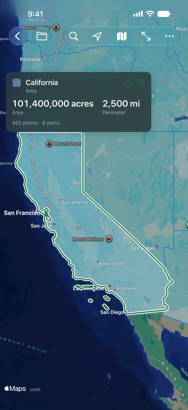
Section titled “The card”The card at the top left of the map says what is selected and the numbers that matter for it, large:
| Selected | The card shows |
|---|---|
| An area | Area and Perimeter; under them its points, parts, and holes (“1 hole, left out of the area”) |
| A path | Length and Points |
| A circle | Area and Radius |
| A place | Its position in your coordinate format, and Altitude when it has one |
| A folder | Placemarks, and the total Area or Length of what is in it |
A time stamp or span the file gives the placemark is under the numbers. The target button (Show on Map) frames the selection on the map, and ✕ closes the card. With My Location on, the card also says how far the placemark is from you.
Change units from the card
Section titled “Change units from the card”Tap an area or a length on the card for a menu of units: Automatic (the unit that suits the size), Acres, Hectares, Square Meters, Square Kilometers, Square Feet, Square Yards, Square Miles, Ares or Tsubo for areas; Meters, Kilometers, Feet, Yards, Miles or Nautical Miles for lengths. The choice is the setting in Settings, so the layer list, the inspector and the Points table follow. Altitudes stay in meters or feet.
Areas and lengths are measured on the earth as Geo Measure measures them, with holes taken out of areas. The file keeps its own numbers: changing a unit never changes the file.
Overlays
Section titled “Overlays”- Ground overlays, an image laid on the map between four edges, are drawn with their image. While the image waits on the web, a dashed outline shows where it goes.
- Screen overlays, legends, logos and titles fixed to the screen, sit where the file places them, in the part of the map the panels don’t cover.
Images from the web
Section titled “Images from the web”Many files link to icons, overlay images and pictures in balloons on the web. KML Explore loads none of them until you say so, so a file from someone else can’t make the app contact a server just by being opened. Meanwhile Google Earth’s standard pins and paddles are drawn by KML Explore itself, in their colors.
When a file links to pictures, a question shows over the map: This map uses N images from the web, with the servers it names.
- Load: loads them for this window.
- Not Now: puts the question away.
- Always: loads web images in every file from now on (the Load Images from the Web setting).
The Map menu has the same choice: Load Images from the Web (the setting) and Load This File’s Web Images. The map itself always comes from Apple Maps.