

Points and the Points table
Editing points needs KML Explore Pro.
On the map
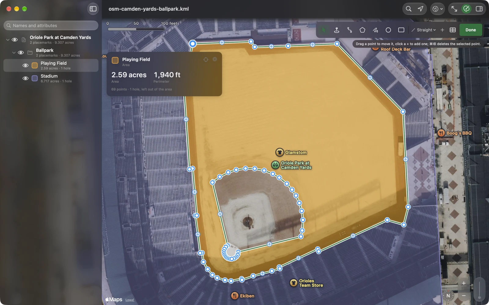
Section titled “On the map”Press Edit, choose Select and Move and click (tap) a path, an area or a place. Its points show as white dots with a blue ring, and a + sits on every edge long enough on screen to take one.
- Drag a dot to move it. A loupe above your finger or pointer shows the ground under it, and the shape follows as you drag.
- Click (tap) a + to add a point there.
- Click (tap) a dot to pick it. Its callout says which point it is, with a delete button.
- Delete a point: the callout’s delete button; on the Mac also Delete or Edit ▸ Delete Selection (⌘⌫). With no point picked, ⌘⌫ deletes the selected placemark.
- ⌥ + an arrow key (Mac) nudges the picked point; see Nudge.
- Esc (Mac) lets go of the picked point, then of the placemark.
A shape with hundreds of points (a county’s outline) shows dots only where they are at least 22 points apart on screen, and only in view. Zoom in for the rest.
A path keeps at least two points and an area three; deleting one more says so. To remove the shape, delete the placemark. A hole left with fewer than three points goes.
The Points table
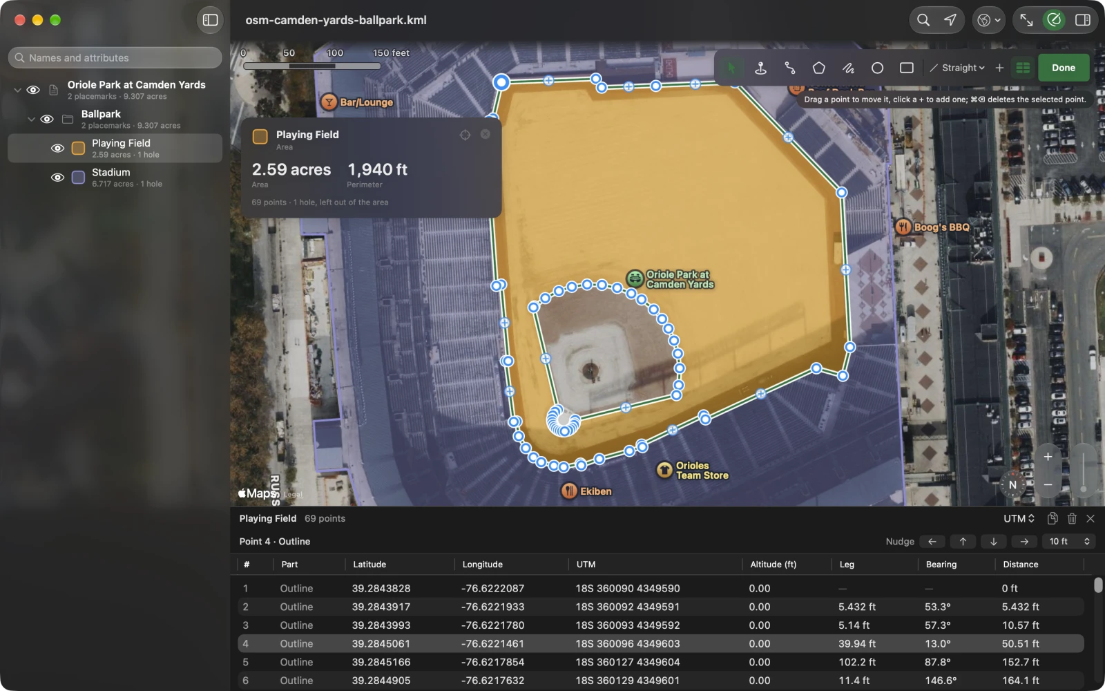
Section titled “The Points table”The Points table lists every point of the selected placemark: under the map on the Mac and the iPad (drag the line above it to resize it), and as a sheet on iPhone that comes down to a row or two while a point is picked, so the point stays in sight above it. Open it with:
- the Points button in the edit bar (⌥⌘P);
- Edit Points… in the inspector’s Shape section, or in the layer list’s menu for a placemark;
- on the Mac, Draw ▸ Show Points Table (⌥⌘P).
It closes with its ✕, with Done, or when you select something without points (a folder, an overlay). It never opens by itself.
The columns
Section titled “The columns”# (through the whole placemark, in the file’s order), Part when there are several (Outline, Hole 1, Path 2, Point 3), Latitude, Longitude, the UTM or MGRS reference when one is your coordinate format, Altitude (m) or (ft), then from the point before in its part: Leg, Bearing, and Distance along the part. A dash means there is no value. Click a column’s title to sort by it.
The header has the placemark’s name, how many points (or how many are selected), the coordinate format menu (DD, DDM, DMS, UTM, MGRS, the same setting as in Settings), Copy as CSV, Delete and ✕.
On iPhone, and where the panel is narrow, the table is a list: each row has the number, the position, the part and altitude, and the leg and bearing. Swipe a row for Delete and Edit; touch and hold for Edit Point…, Show on Map, Copy Coordinates and Delete.
Pick and type
Section titled “Pick and type”A row picked in the table is the point picked on the map, and the map keeps it in view below the card and the edit bar. Right-click a row (touch and hold) for Edit Point…, Show on Map, Copy Coordinates, Copy as CSV and Delete. On the Mac a double-click shows the point on the map.
On the Mac, type into the cells. Select one row, then click its latitude, longitude, grid reference or altitude:
- Return writes it; ↑ and ↓ write it and move a row, as in a spreadsheet; Tab or a click elsewhere writes it too.
- Type in the format the column shows: decimal, degrees and minutes, or degrees, minutes and seconds.
- Paste a whole coordinate into the latitude, longitude or grid cell, in any format (
40.78255N, 73.96566W,18T 585785 4511904), and the point moves there. - Empty the altitude to remove it.
Edit Point… (every platform) opens a form for one point with Latitude, Longitude, the grid reference when one is chosen, and Altitude, each typed or pasted in any format. An empty altitude means none.
Decimal cells show seven decimals, about a centimeter, which is what KML keeps.
With one point picked, the bar above the table moves it North, South, East or West by the step beside the arrows: 0.1 m, 1 m or 10 m (1 ft, 10 ft or 100 ft in US units). Hold an arrow to repeat. On the Mac, ⌥ + an arrow key does the same in the table and on the map. The map zooms in when a step would be too small to see. Each nudge is one step of undo.
Several points
Section titled “Several points”On the Mac, ⌘-click or Shift-click rows to pick several, then press Delete, ⌘⌫ or the trash: they go together, in one step of undo, across the outline and holes too. The minimums still hold (two for a path, three for an area), and picking every point of a placemark deletes the placemark. Copy as CSV copies the picked rows, or every row when none is picked, ready to paste into a spreadsheet.