
Names, attributes and styles
Editing needs KML Explore Pro.
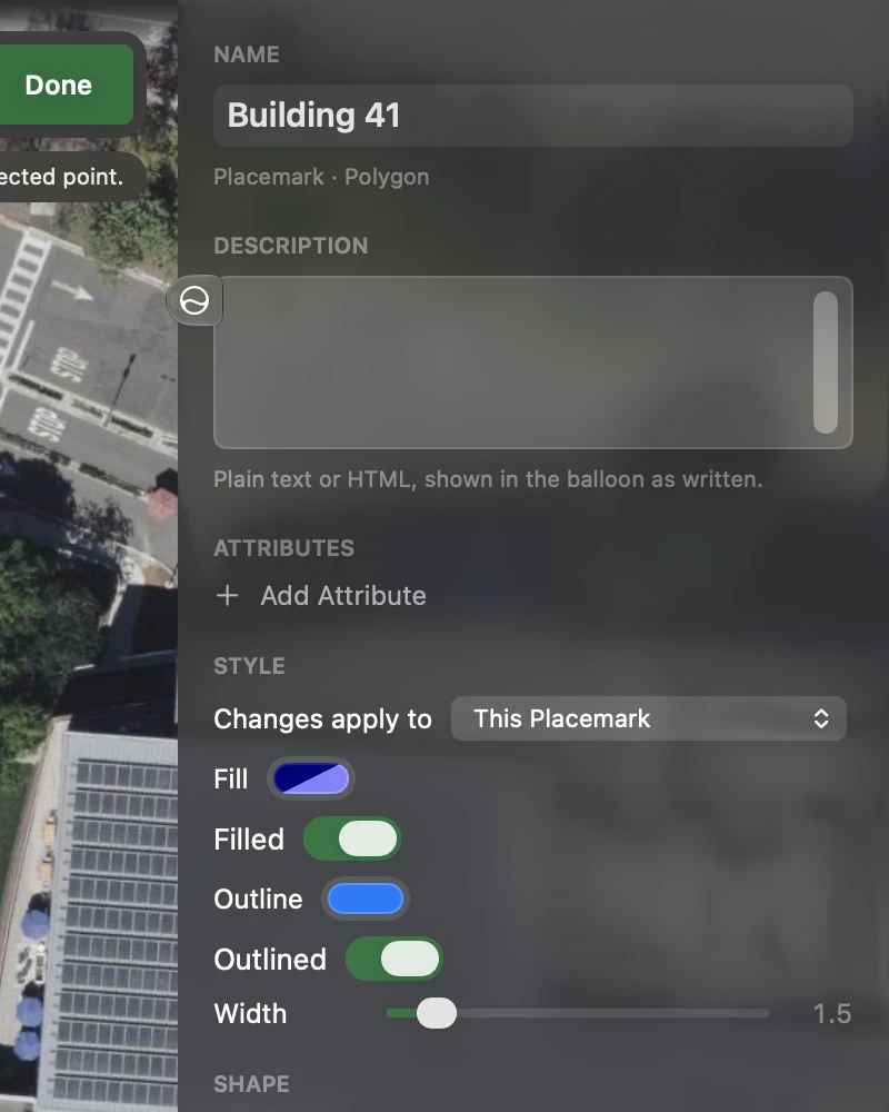
While editing, the inspector shows the selection as fields. A field is written to the file when you press Return or leave it, one step of undo each; colors and sliders write as they move, and a run of them is one step. The rendered balloon stays below the fields, under Balloon, so you see what your description looks like. On iPhone, tap the Inspector button at the right of the toolbar for these fields.
Name and description
Section titled “Name and description”- Name: the placemark’s or folder’s name. In the layer list, Rename… (right-click or touch and hold) does the same.
- Description: plain text or HTML, shown in the balloon as written. HTML is kept in a CDATA section so other apps read it the same way.
Attributes
Section titled “Attributes”Each attribute is a name and a value. Type a new value, or for an attribute of the placemark’s own, a new name; the – button deletes one, and Add Attribute adds one (named attribute, ready to rename). An attribute defined by the file’s schema keeps its name, which every placemark using the schema shares; point at it on the Mac for Defined by the file’s schema.
Styles
Section titled “Styles”For a path: Line color and Width. For an area: Fill and Filled, Outline and Outlined, and Width. For a place: Icon, Icon color, Icon size and Name size. Colors can be partly transparent.
Icon offers Google Earth’s standard icons, in three groups: Pushpins, Paddles and Shapes (stars, flags, a hiker, parks, campgrounds, water, hospitals and more). They are Google’s own web addresses, so Google Earth shows them too; KML Explore draws them itself until web images load.
When the placemark uses a shared style, Changes apply to chooses where a change goes:
- This Placemark (the default): the placemark gets a style of its own on top of the shared one, and nothing else changes.
- All N Using #style: the shared style itself, for every placemark that uses it.
Use the Shared Style Again takes this placemark’s own style away, so it looks as the shared style says.
Height
Section titled “Height”For a placemark with points, paths or areas, Height is Google Earth Pro’s Altitude tab:
- On the Ground (the default): drawn on the ground, whatever heights the points carry.
- Above the Ground, or Above Sea Level: then Altitude sets one height for every point (
30 m,100 ft, or a number in meters or feet as Settings says), and Extend to the Ground draws walls down from the shape, as Google Earth does in 3D.
Parts that differ show as Mixed, and each control changes only its own setting, on every part. A Google sea-floor mode the file uses is shown and kept as it is.
Position
Section titled “Position”For a place: Latitude and Longitude in decimal degrees, and a field in your
coordinate format (degrees, minutes and seconds when that is decimal), which takes a
position typed or pasted in any format: 40.7536, -73.9838; 40° 45′ 13″ N, 73° 59′ 2″ W; 18T 585785 4511904;
18T WL 85784 11903. The place moves there and keeps its altitude.
For a path or an area, the Shape section has the point count, the area and perimeter or the length, Add a Hole, Simplify…, Reverse, Make an Area or Make a Path, and Edit Points…. For a circle, the Circle section has its Radius; see Circles.
A ground overlay’s placement
Section titled “A ground overlay’s placement”For a ground overlay, Placement has its North, South, East and West edges in decimal degrees and its Rotation, so an image (a site plan, a scanned map) can be fitted to the map.
Duplicate and Delete
Section titled “Duplicate and Delete”At the foot of the inspector: Duplicate makes a copy right after the feature (with new ids, so both stay valid KML), and Delete removes it. Both can be undone.