

Go To a mark
Go To leads you to one mark. Start it by tapping a mark on Marks, by Go To in a pin’s menu on Map, or by Go To in a mark’s Details. With no mark chosen, the tab lists your marks nearest first under Pick a mark to walk to.
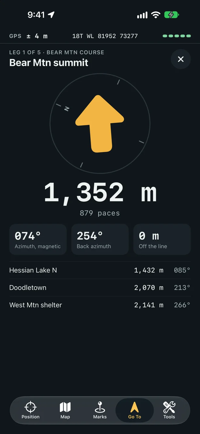
What the screen shows
Section titled “What the screen shows”| Part | Means |
|---|---|
| The arrow | Points at the mark as you turn. The ring around it turns with the compass; N is north. |
| The distance | How far the mark is, in meters up to ten kilometers and then in kilometers, or in feet and miles if Settings say so. |
| Paces | The distance in your own paces, from your pace count. |
| Azimuth | The direction to walk, with the north it is from (Azimuth, grid). |
| Back azimuth | The way back: the azimuth turned by 180°. |
| Off the line | How far you have drifted left (L) or right (R) of the straight line from where the leg began. |
Hold the phone flat with its top pointing ahead of you. If the screen says No compass: the arrow assumes the top of the phone points north., read the azimuth and walk it with a hand compass.
The X at the top right stops the leg.
The azimuth and its north
Section titled “The azimuth and its north”The azimuth is measured from the north you chose in Settings: grid north unless you changed it. The caption always names the north. Where the chosen north cannot be had, the app uses true north and says true: there is no grid north beyond 84° north and 80° south, and no magnetic azimuth until the phone knows the declination. See Grid, magnetic and true north.
Off the line
Section titled “Off the line”The line runs from where the leg began to the mark. A leg begins where you stood when you started it, or at the mark you just reached when you tap Next. If you start a leg before the phone has a position, the line begins at the first position it gets.
The card turns to the accent color when you are farther off the line than 10 m, or than the GPS ±, whichever is larger. Under that, the drift is within what the GPS can tell.
Arriving
Section titled “Arriving”The screen reads You’re there and the arrow gives way to a still mark when you are within 15 m. When the fix is loose the circle widens to the GPS ±, but never past 25 m. The phone taps once, unless Haptics is off.
Walk away and come back, and it is an arrival again.
A folder is a course
Section titled “A folder is a course”Put the marks of one route in a folder and Go To treats them as a course, in the order the marks were made.
- The header reads Leg 2 of 5 and the folder’s name.
- Under the cards, the next three legs are listed, each with its distance and azimuth measured from the mark before it.
- On arrival, Next: and the next mark’s name starts the next leg from the mark you reached, so off the line is measured along the leg as drawn on the map.
- On Marks, make a folder and put the course’s marks in it, in walking order. See Folders.
- Tap the first mark.
- Walk the azimuth, counting paces, until You’re there.
- Tap Next.
The same folder is drawn as a line on the map.